New Year, New Adventure- Part 5 of 5

At 0800 on our second to last day of vacation, The Captain successfully booked an El Yunque National Forest reservation for the next day. We were happy that the opportunity didn’t escape us, but it meant that we had to close out anything we wanted to do elsewhere now. What was number one after El Yunque? The other fort in San Juan, the Castillo San Cristóbal. It also meant that today was the day for protracted lounging by the pool, because we had no idea how much time the trip to El Yunque would consume. With those conditions set, we devised a plan. See the fort in the morning, general tropical laziness in the afternoon, followed by early morning ride to the jungle.

Looking towards the Plaza de Colón. Castillo San Cristóbal dominates the center of the island on which San Juan was built.
We were blessed with a beautiful clear sky for our second excursion into Old San Juan. The presence of cruise ships in the harbor pretty much guaranteed no rain for the morning. (I’ve heard the cruise companies secretly pay extra to the National Weather Service to insure clear skies on on port call days. They also hire schools of dolphins to frolic near the ship when entering harbor.) The short drive was easy and there was ample parking in the municipal garage by the cruise ship pier. From there it was an easy walk up to the Castillo.
Situated on a hill named San Cristóbal, the fortification was built to prevent land and sea attack from the east. It spanned from the beach on the Atlantic to the shore line on the harbor. Built on several levels, the walls feature protected tunnels to allow troop movement, and out structures to provide defense in depth. It is considered a masterpiece of 18th century military engineering and took 150 years to complete. To accommodate the expanding town, a section of the harbor wall was taken down during the end of the Spanish colonial period. After the signing of the Treaty of Paris in December of 1898, the US Army took over. It was improved and re-armed through WWII and even hardened for Nuclear, Biologic, and Chemical attack during the Cold War. In 1961, the National Park Service took over, and for the first time since 1634, when a small redoubt was first built on the hill, San Cristóbal was not a military post.

Looking west from highest point of the fort, city’s wall can be observed all the way to El Morro at the harbor entrance.
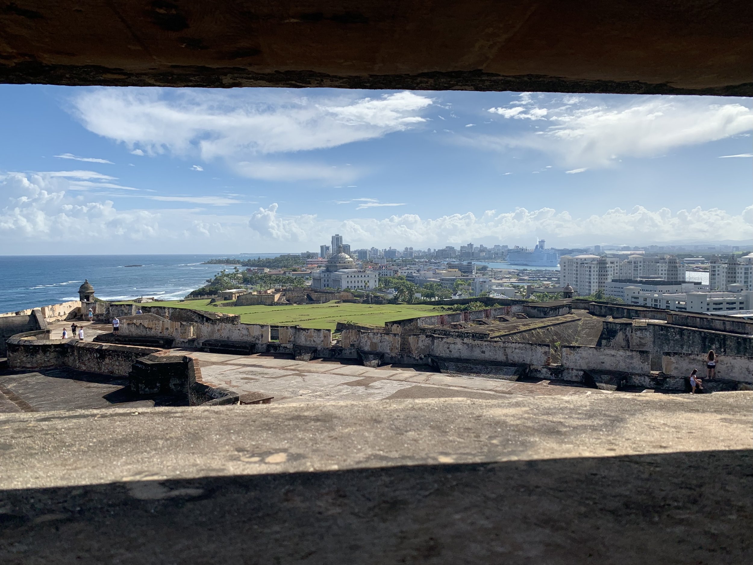
Looking east from the upper casemate, the outer defenses dominate the territory’s capital building. The eastern end of the harbor and Condado are visible in the distance.

Numerous tunnels snake under and through the walls. At the bottom of one tunnel is a “dungeon” known to have been used for prisoners.

The central plaza of the fort. The circular walls protect the access shafts to the cisterns under the fort.
The yellow structure is a chapel dedicated to Santa Barbara, the patron saint of artillerymen.
Our tour was pretty thorough, and by the time we finished, we had climbed enough steps and ramps to earn the rest of the day off. We returned to the car after a short down-hill meander through the Plaza de Colón. There wasn’t much interesting activity, except the swarm of cruise ship passengers wandering through the shops, so we took our leave and returned to the hotel for lunch and a lazy afternoon.
Our final full day started early. We had a good hour drive east, mixed with the joys of Monday morning rush hour traffic. The first thing we learned was that Puerto Rico has snazzy school transport. Exiting Condado’s surface streets and onto the freeway, we saw a small convoy of decked out busses. Polished stainless steel trim, rows of LED lights, custom window tinting, and polished wheels made these busses way cooler than Mrs. McNutt’s bus #10 that I rode in grade school.

RIGHT ON!
The congested drive smoothed out after the first toll plaza on east-bound highway 66, and we made good time to the entrance to El Yunque. The morning weather was pretty decent and we only got a few sprinkles as we went. Turning up into the hills, the road narrowed and became enclosed in a foliage tunnel. From sea-level, we climbed up and up. Soon there were guard rails along the east side of the road, protecting against inadvertent cliff diving. On the other side of the road, streams formed dramatic waterfalls. Along the way there were pull-outs for catching a glimpse of the scenery. About half way up, the Yakahú Tower let visitors climb above the foliage level for unobstructed views. Along the way, several trails led to waterfalls and other points of interest. We continued as far as the road would allow, and parked near the restrooms and vendor outpost at the bottom of the Mt. Britton trail. After getting our affairs in order, we started up the mountain. The signs clearly indicated the trail isn’t easy, it’s .8 miles, gains something like a thousand feet and will take the better part of an hour each way. The sign was right. It leads steeply up into what’s called the “cloud forest.” Basically that means nearly constant precipitation and mist. The trees absorb sound and the trail snakes around enough to block the view ahead or behind. I couldn’t help but wonder when and what kind of dinosaur was going to come out of the bushes and eat us.
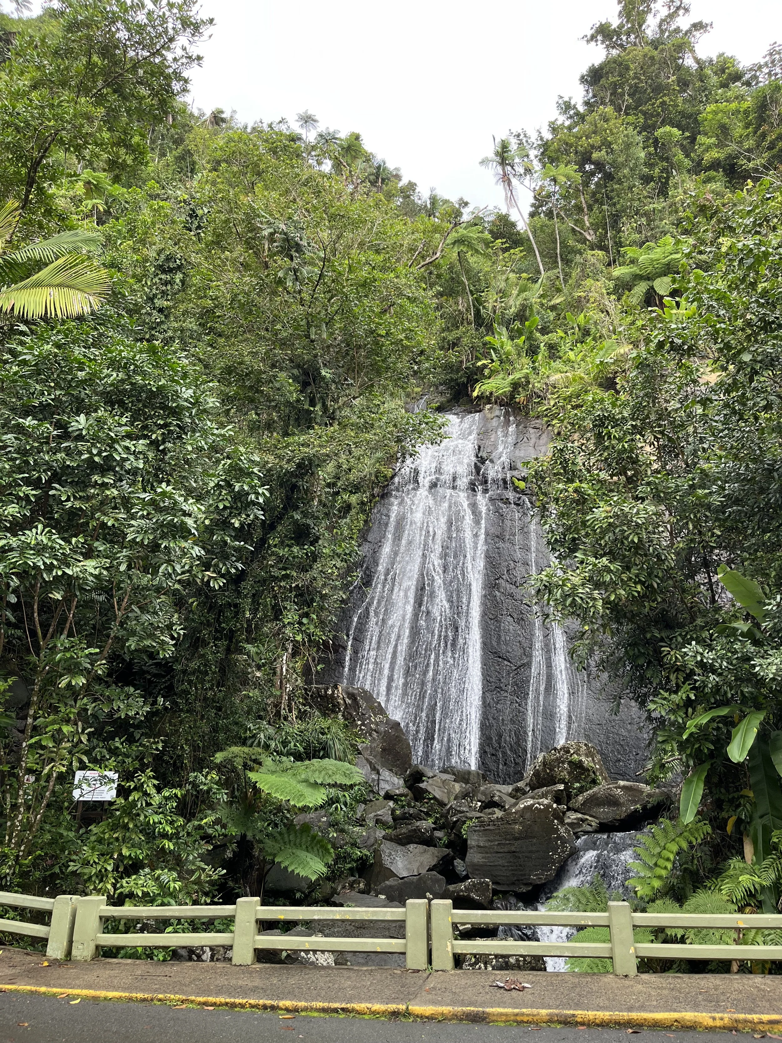
Waterfalls abound when the surrounding area gets 200 inches of rain each year.

Looking up the mountain from the Yakahú Tower.

The trail is paved, but expect to get wet and muddy. The concrete protects the soil from erosion caused by thousands of visitors, but doesn’t protect visitors from slipping and falling.

Clouds drift across the top of the mountain, bringing endless moisture to the “cloud forest.”

A gap in the clouds let us see the north east corner of the island and the Las Cabezas de San Juan Reserva Natural.
The descent from the Mt. Britton Tower was just as difficult as the climb, and took just as long. We drank a lot of water and rested a few times. Our early arrival meant there weren’t many folks on the trail with us, but coming down, we saw large groups just starting out. Knowing what was ahead of them, The Captain and I shook our heads in disbelief at some of the footwear and clothing choices. Well, at least it is downhill if it doesn’t work out.
Back at the trailhead, we visited the services offered near the parking lot. We didn’t have a lunch plan, so we bought a vendor’s sample plate of local foods and hung out on the patio. When we were satisfied and rested, we returned to the Hyundai, changed shoes and shirts, and started back down towards the highway and the hotel in Condado.
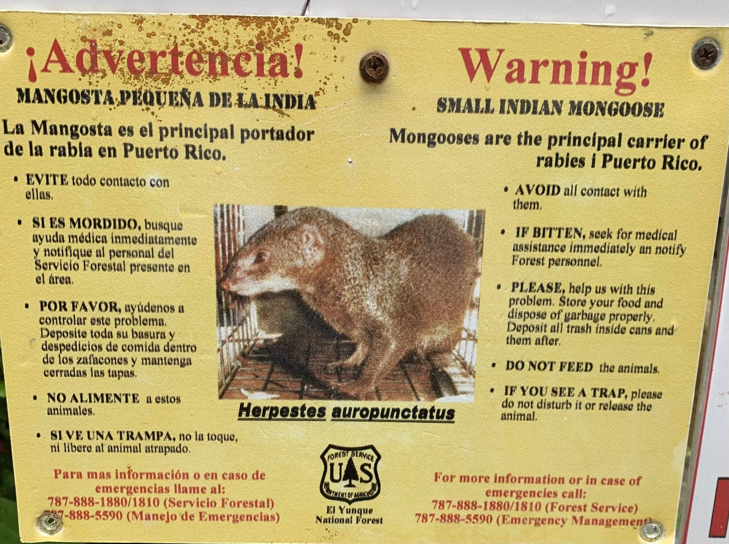
We didn’t see any mongoose or dinosaurs, just a few birds.

Baño Grande is an old tourist attraction swimming hole. While entering the water isn’t permitted anymore, we were refreshed by a rain shower while checking it out.

El Yunque is a beautiful place, but it is very wet.
We returned to the hotel in time to recover in the hot tub before heading out to our last island dinner. As tired as we were, we didn’t see any point in walking further than the stone fired pizza place across the street. The next day was spent getting packed and traveling back to Ohio via Miami. Everything went according to plan with no complications. (Thanks Willa!) It was even a few degrees above freezing for our arrival back at KCMH. Perhaps the best stroke of luck? We missed the NOTAM computer malfunction and nationwide flight grounding by a few hours. (https://news.yahoo.com/faa-grounds-us-flights-notam-computer-outage-124946230.html)

Departing San Juan, Puerto Rico. Thanks for the adventures!